
The Lake to Lake Route is now complete, with final landscaping underway and set to be completed later this fall. This protected bike lane stretches approximately 6 km through the centre of the city, intended to make cycling convenient and safe for residents of all ages and abilities.
This route provides a safe and convenient cycling option for residents of all ages and abilities, connecting Okanagan Lake to Skaha Lake. Roughly 120,000 trips were measured along the partially completed route in 2024. Also, a substantial portion of the project's funding has been provided by strong support from both provincial and federal governments. To date, they have contributed roughly 70% of the total cost.
Project Funding
-
The total cost of the Lake-to-Lake Route is estimated at $9.1 million. This estimate includes all costs associated with the separated bike lanes, intersection and crossing improvements, street lighting improvements that will benefit all road users, as well as storm system alterations along the route.
A substantial portion of the project's funding has been provided by strong support from both provincial and federal governments. To date, they have contributed roughly 70% of the total cost. This includes $1 million from the Community Economic Recovery Infrastructure Program, $750,000 from the Canada Community Revitalization Fund, $2.2 million from the Canada Community-Building Fund, $1 million from the Provincial Active Transportation Fund, $840,000 from the Federal Active Transportation Fund, as well as miscellaneous amounts from ICBC’s Road Improvement Program. The City has also applied for a Federal Tree Planting Grant for some of the landscaping work that is currently underway.
The cost for the route was originally estimated to be $8 million when the alignment was first selected in 2020. Largely due to construction cost escalation over the past five years, the final cost is now estimated at $9.1 million. However, contributions from a variety of Provincial and Federal programs, now over $6.3 million, have largely offset the city's financial contribution.
-
The following provides a timeline of this ongoing initiative.
In 2012, Urban Systems developed a report for the City highlighting a need for a safe and convenient cycling route connecting Okanagan and Skaha Lakes. Following consultation with stakeholders, Council adopted an updated Bike and Cycling Network map into the 2019 Official Community Plan.
June 18, 2019: City Council endorsed the project to identify the location of the Lake to Lake Route. The project involved an extensive engagement process and a technical analysis to determine the preferred route.
Sept. 6, 2019: The City hosted “Pedal Penticton,” a community-wide cycling event to gather input into the work to identify the Lake to Lake Route. Approximately 500 people attended the event and the City received input from more than 1,000 individuals.
June-July 2020: The City conducted a targeted engagement program to ensure feedback was received from businesses and residents in the downtown area.
Nov. 17, 2020: Council amended the Official Community Plan to approve the alignment of the route after holding a Public Hearing on the proposed amendments on Nov. 16, 2020.
Dec. 8, 2020: Council endorsed staff working with affected landowners, residents and businesses along the proposed route, identifying issues and developing design solutions.
Feb. 2, 2021: City staff presented an updated design for sections 3 and 4 of the route based on feedback received. This included relocating the cycle track from the west side of Martin Street to the east side, allowing for existing patios to be retained and no significant impacts to the 200-block revitalization works.
Feb. 25, 2021: The City was awarded a $1 million grant from the provincial government to construct sections 3 and 4 of the route.
March 31, 2021: Council approved the detailed design endorsement for sections 3 and 4 of the route, directing staff to proceed to construction design work.
May to July 2021: Construction was underway on sections 3 and 4 of the route starting from Lakeshore Drive through the downtown area to Duncan Avenue.
Aug. 1, 2021: Official opening of the first sections of the Lake-to-Lake Bike Route.
Nov. 18, 2022: Construction of section 2 was completed, which included a new signalized intersection at Duncan Avenue and Atkinson Street, a new cyclist-activated signal and pedestrian crossing at Baker Street and Duncan Avenue, the widening of Atkinson Street Bridge at Ellis Creek, and infrastructure improvements including upgrades to storm water management, enhanced lighting and increased sidewalk connectivity.
Dec. 2, 2022: The Government of Canada announces funding of $750,000 for the development of the Lake-to-Lake Bike Route.
March 2022: Consultation gets underway for section 2 of the route.
January 2023: Detailed design for the final section of the Lake to Lake Route gets underway. This section will see the route continue from the Point Intersection (at Galt Ave. and South Main St.) along South Main St. to its terminus at Skaha Lake Park.
April 2024: Construction on the Point Intersection group of projects began, which involves a section of bike lane along Kinney Avenue.
Fall 2024: Construction of section 1, the final section, will begin.
Winter 2024: Work will continue south of Green Avenue as long as weather permits, and will resume in Spring 2025.
Summer 2025: Construction of Section 1 completed.
City Updates
-
- May 30, 2025: Biking and outdoor events set to attract extra pedal and foot traffic
- May 14, 2025: Temporary no parking rolls out on South Main Street
- March 20, 2025: South Main Market open during construction, follow detours
- February 27, 2025: Construction returns to South Main
- January 15, 2025: Milder weather resumes construction along South Main Street
- October 15, 2024: Businesses open as usual as roadwork continues on South Main
- October 9, 2024: Voting at Seniors' Drop-In Centre during construction
- October 8, 2024: Roadwork will continue south of Green Avenue and South Main Street Intersection
- October 1, 2024: Expect delays at intersection of Green Avenue and South Main Street during roadwork and electrical upgrades
- Sept. 11, 2024: Work on final section of Lake to Lake Route ready to begin
- May 10: 2024: Point Intersection construction ready to shift to South Main Street and Kinney Avenue
- April 2, 2024: Province provides Active Transportation Grant
- March 15, 2024: Government of Canada contributes $840,000 to Penticton’s Lake to Lake Bike Route through Infrastructure Canada’s Active Transportation Fund
- June 20, 2023: Dates set to review design of final section of Lake-to-Lake Route
- June 14, 2023: City reaches agreement with South Main Market
- April 24, 2023: Construction set to begin on Point Intersection projects
- Feb. 17, 2023: City awarded $500,000 towards Lake-to-Lake cycling route
- Jan. 19, 2023: City begins detailed design on final section of Lake-to-Lake Route
- Dec. 7, 2022: Government of Canada announces $750 funding for Lake-to-Lake Bike Route
- Nov. 18, 2022: Construction wraps up on latest section of Lake-to-Lake Bike Route
- Sept. 12, 2022: Lake-to-Lake Bike Route gears up for final leg of section 2 construction
- Aug. 25, 2022: Lake-to-Lake Bike Route construction on Duncan Avenue set to begin
Ridership Data
-
The data shows that cycling continues to climb each year as a desirable mode of transportation in Penticton. In fact, we have seen 20-30% growth annually on the route since the first section was complete.
Image
Annual bike trips through the intersection of Eckhardt & Martin Total 2022 75,343 2023 96,633 2024 119,911 Spring bike trips at Eckhardt & Martin Average daily cyclists Total monthly cyclists May 2022 316 9,781 May 2023 370 11,460 May 2024 475 14,745 Summer bike trips at Eckhardt & Martin Average daily cyclists Total monthly cyclists August 2023 421 13,045 August 2024 636 19,744

Frequently Asked Questions
The City has received a number of questions about the Lake to Lake Route. Here are the answers to the most frequently asked questions. Email communications@penticton.ca if you have any additional questions.
-
We understand that adjustments to road layouts can present challenges as residents adapt to the changes.
The new design of South Main Street was intentionally created to help reduce vehicle speeds by reducing lane widths, creating parking pockets and installing “floating” bus stops.
This design addresses safety concerns associated with the previous straight and wide sections of South Main Street, which encouraged higher speeds. It also allows for on-street parking on the side of the street that is generating demand.
The design also includes “floating” bus stops, which create the accessible landing area for bus riders separate from the protected cycling infrastructure, which follows best practices to ensure the safety of all road users.
Staff will continue to monitor how the changes are functioning as the work is completed and once it is fully operational – and make adjustments as required.
-
Through the creation of the recent Official Community Plan (OCP), the community identified moving towards a “complete transportation approach” as a priority. A complete transportation approach aims to create a safe transportation system that supports all ages, abilities and modes of transportation and prioritizes investment in active transportation.
(Watch this video to learn more about how the OCP will influence transportation in the city.) One of the main recommendations in this section of the plan is to create a pathway within City limits connecting Skaha Lake and Lake Okanagan that is separated from motorized traffic, has minimal grade changes, and has connections to key destinations.
Developing a cycling network also works toward the City's Climate Action Plan goals, which involves reducing vehicle kilometres travelled by 13%.
Also, investments in active transportation can result in a more balanced transportation system that is accessible, cost-effective and improves quality of life for community members. This includes:
- Environmental benefits
- Economic benefits
- Health benefits
- Societal benefits
- Safety benefits
See pages 32, 34 and 35 in the B.C. Active Transportation Design Guide
-
The City uses the curbs to create vertical separation between the cyclist and vehicles. The buffer zone is the area that provides the physical separation between people cycling and moving, or parked motor vehicles. The protected bike lanes are suitable for all ages and abilities (AAA).
What does this mean?
There are a wide spectrum of riders, with the majority of those being interested in riding but concerned about safety. Each person has different motivations, barriers, preferences and needs. By adding barriers to protect the bike lanes, it is not in response to a specific accident or history of incidents, but rather to entice more people to use cycling as a form of transportation.

These categories include the following (from page 47 in the B.C. Active Transportation Design Guide):
Strong and Fearless (approximately 2-6% of the population): People who are generally comfortable riding on major roads, regardless of motor vehicle volumes or speeds, weather conditions, or the presence of existing bicycle facilities. These people often prefer to use the most direct routes to their destination, regardless of whether bicycle facilities are provided.
Enthused and Confident (approximately 9-28% of the population): People who are generally comfortable on most roads with bicycle facilities. These people may select a route with lower motor vehicle volumes or speeds, or separated facilities where provided, over a more direct route.
Interested but Concerned (approximately 37-60% of the population): These people often own a bicycle but do not ride frequently due to concerns about the safety of cycling. They are interested in cycling more, but usually restrict their riding to roads with physically protected facilities or lower motor vehicle volumes and speeds. The ‘interested but concerned’ segment of the population is typically found to be the largest segment of the population in communities of all sizes and contexts. There is a significant opportunity to focus on the needs of this large market segment to achieve a substantial increase in regular bicycle ridership. To do so, many communities throughout B.C. are now focusing on developing bicycle networks with an emphasis on all ages and abilities facilities.
No Way, No How (approximately 25-38% of the population): This group may be uninterested or unable to ride a bicycle, or they may perceive severe safety issues with cycling in motor vehicle traffic. A significant portion of this group will likely never choose to ride a bicycle under any circumstances, although some may eventually choose to ride given enough time and education.How do cities pick which bike facility to use?
This chart shows how we pick which type of facility is appropriate. Generally, protected facilities are recommended where you have higher volumes of traffic and higher speeds.

-
The data shows that cycling continues to climb each year as a desirable mode of transportation in Penticton. In fact, we have seen 20-30% growth annually on the route since the first section was complete, despite it not yet being complete or connected to a larger protected network.
There were 96,633 trips by bike through the intersection of Eckhardt Avenue and Martin Street in 2023 alone, in comparison to 75,343 in 2022. As of Sept. 12, 2024, the total bike rides through this intersection stands at 96,040, on track to far surpass 2023 numbers.
Spring bike trips at Eckhardt & Martin Average daily cyclists Total monthly cyclists May 2022 316 9,781 May 2023 370 11,460 May 2024 475 14,745 Summer bike trips at Eckhardt & Martin Average daily cyclists Total monthly cyclists August 2023 421 13,045 August 2024 636 19,744 Annual bike trips at Eckhardt & Martin 2023 2024 Jan. 1 - Sept. 12 75,343 96,040 Total annual 96,633 Image Image
Image
-
The total cost of the Lake-to-Lake Route is estimated at $9.1 million. This estimate includes all costs associated with the separated bike lanes, intersection and crossing improvements, street lighting improvements that will benefit all road users, as well as storm system alterations along the route.
A substantial portion of the project's funding has been provided by strong support from both provincial and federal governments. To date, they have contributed roughly 70% of the total cost. This includes $1 million from the Community Economic Recovery Infrastructure Program, $750,000 from the Canada Community Revitalization Fund, $2.2 million from the Canada Community-Building Fund, $1 million from the Provincial Active Transportation Fund, $840,000 from the Federal Active Transportation Fund, as well as miscellaneous amounts from ICBC’s Road Improvement Program. The City has also applied for a Federal Tree Planting Grant for some of the landscaping work that is currently underway.
The cost for the route was originally estimated to be $8 million when the alignment was first selected in 2020. Largely due to construction cost escalation over the past five years, the final cost is now estimated at $9.1 million. However, contributions from a variety of Provincial and Federal programs, now over $6.3 million, have largely offset the city's financial contribution.
-
The City conducted a 19-month process to involve the community in the identification of the route. The process was conducted in multiple phases allowing for ongoing participation as the location was narrowed down and finalized. All feedback gathered through the process was made available publicly and can be found on shapeyourcitypenticton.ca.
-
The City frequently receives comments that there are already bike routes in the City that are underutilized. The City adopted a Cycling Network Plan in 2012 that identified the routes needed to make cycling a viable mode of transportation. The City has made some progress in adding the bike lanes identified in the plan such as those on Government St. and with this project, the spine of the network will be completed.
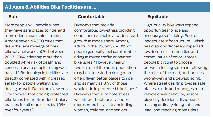
It is important to note that the Lake-to-Lake Bike Route is the first protected bike route in the city that is safe for cyclists of All Ages and Abilities (AAA) and through community survey the City learned that safety is the number one reason why there are not more cyclists on the roads today.
-
Changes were made to the curbs at the intersections on Martin to reduce the distance that cyclists and pedestrians are exposed to vehicle traffic when crossing and reduce the gap that vehicles need to pay attention to as they pass through the intersection. This is a best practice design for Age-Friendly communities as well. It has the added benefit of slowing vehicles down which has been a frequent concern on Martin St.
-
Research has found that protected bicycle lanes are the safest type of bicycle facility. The Cycling in Cities Program at the University of British Columbia found that protected bicycle lanes were the safest type of bicycle facility, with a 90% decrease in safety risk compared to a major street with no cycling infrastructure. (*see reference 1)
Another recent study examined 13 years of data from 12 large U.S. cities, including 17,000 fatalities and 77,000 severe injuries. The study found that cities with protected bicycle lanes had 44% fewer deaths and 50% fewer serious injuries than the average city. Furthermore, the study found that painted bicycle lanes provided no road safety improvements, and that shared use lanes were actually less safe than having no pavement markings at all. (*see reference 2)
*1 Kay Teschke et al., ‘Route Infrastructure and the Risk of Injuries to Bicyclists: A Case-Crossover Study’ (2018).
*2 Marshall and Ferenchak, ‘Why Cities with High Bicycling Rates are Safe for All Road Users’ (2019). -
The Lake to Lake Bike Route is the City's first All Ages and Abilities cycling route. An AAA bike route meets the needs of a broad range of people who want to bike or roll. This could be children, seniors, people riding bike share, low-income riders, those with disabilities, people moving goods or cargo, as well as confident cyclists.
View this NACTO report about Designing for All Ages & Abilities


Contact Us
For questions about bike lanes, contact the Engineering Department. To make a suggestion or report a concern, please use our online form.
Engineering Department
Phone: 250-490-2521
Email: engineering@penticton.ca