Cycling Network
Our bike-friendly city is home to a growing network of paths and routes that will connect you to lakes, parks, schools and businesses. Thanks to Penticton's compact geography, combined with great weather for most of the year, cycling is an ideal way to move around the community. Also visit our Trails page to scope out your off-road routes.
By the Numbers
- On street painted bike lanes – 22 km
- All Ages and Abilities bike lanes – 2.3 km
- Multi-use paths and trails – 25 km
Frequently Asked Questions
54% of our community emissions are created by vehicles. In addition to electrification, in order to achieve the targets in the Community Climate Action Plan relating to vehicle emissions, the City is striving to reduce vehicle kilometres travelled by 13%. The City plans to do this by:
- Eliminating approximately a quarter of the kilometers travelled by better land use planning (locating housing close to services/commercial)
- Converting almost half of the kilometers travelled to active transportation (biking, walking, scooters etc)
- Converting the remaining quarter to transit trips
In addition, the community will have to ensure that these efforts are not offset by new trips as the community grows.
The Lake to Lake Bike Route is the City's first All Ages and Abilities cycling route. An AAA bike route meets the needs of a broad range of people who want to bike or roll. This could be children, seniors, people riding bike share, low-income riders, those with disabilities, people moving goods or cargo, as well as confident cyclists.
View this NACTO report about Designing for All Ages & Abilities
Investments in active transportation can result in a more balanced transportation system that is accessible, cost-effective and improves quality of life for community members. This includes:
- Environmental benefits
- Economic benefits
- Health benefits
- Societal benefits
- Safety benefits
See pages 32, 34 and 35 in the B.C. Active Transportation Design Guide
There are a wide spectrum of riders, with the majority of those being interested in riding but concerned about safety. Each person has different motivations, barriers, preferences and needs.
By adding barriers to protect the bike lanes, it is not in response to a specific accident or history of incidents, but rather to entice more people to use cycling as a form of transportation.
These categories include the following (from page 47 in the B.C. Active Transportation Design Guide):
Strong and Fearless (approximately 2-6% of the population): People who are generally comfortable riding on major roads, regardless of motor vehicle volumes or speeds, weather conditions, or the presence of existing bicycle facilities. These people often prefer to use the most direct routes to their destination, regardless of whether bicycle facilities are provided.
Enthused and Confident (approximately 9-28% of the population): People who are generally comfortable on most roads with bicycle facilities. These people may select a route with lower motor vehicle volumes or speeds, or separated facilities where provided, over a more direct route.
Interested but Concerned (approximately 37-60% of the population): These people often own a bicycle but do not ride frequently due to concerns about the safety of cycling. They are interested in cycling more, but usually restrict their riding to roads with physically protected facilities or lower motor vehicle volumes and speeds. The ‘interested but concerned’ segment of the population is typically found to be the largest segment of the population in communities of all sizes and contexts. There is a significant opportunity to focus on the needs of this large market segment to achieve a substantial increase in regular bicycle ridership. To do so, many communities throughout B.C. are now focusing on developing bicycle networks with an emphasis on all ages and abilities facilities.
No Way, No How (approximately 25-38% of the population): This group may be uninterested or unable to ride a bicycle, or they may perceive severe safety issues with cycling in motor vehicle traffic. A significant portion of this group will likely never choose to ride a bicycle under any circumstances, although some may eventually choose to ride given enough time and education.How do cities pick which bike facility to use?
This chart shows how we pick which type of facility is appropriate. Generally, protected facilities are recommended where you have higher volumes of traffic and higher speeds.
The route was designed by professional transportation engineers. The City uses the B.C. Active Transportation Design Guide as its primary design reference.
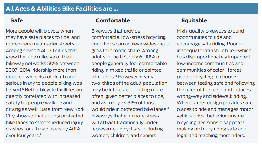
Research has found that protected bicycle lanes are the safest type of bicycle facility. The Cycling in Cities Program at the University of British Columbia found that protected bicycle lanes were the safest type of bicycle facility, with a 90% decrease in safety risk compared to a major street with no cycling infrastructure. (*see reference 1)
Another recent study examined 13 years of data from 12 large U.S. cities, including 17,000 fatalities and 77,000 severe injuries. The study found that cities with protected bicycle lanes had 44% fewer deaths and 50% fewer serious injuries than the average city. Furthermore, the study found that painted bicycle lanes provided no road safety improvements, and that shared use lanes were actually less safe than having no pavement markings at all. (*see reference 2)
*1 Kay Teschke et al., ‘Route Infrastructure and the Risk of Injuries to Bicyclists: A Case-Crossover Study’ (2018).
*2 Marshall and Ferenchak, ‘Why Cities with High Bicycling Rates are Safe for All Road Users’ (2019).The City is using the curbs to create vertical separation between the cyclist and vehicles. The buffer zone is the area that provides the physical separation between people cycling and moving, or parked motor vehicles, and can generally be horizontal or vertical.
By using the curbs, the City has been able to mostly stay within the existing road width, making the projects very cost effective relative to other design solutions (reconstructing the curb, and/or sidewalk increases the costs by at least 3-4 times).
Recreational Riding
Visit our Trails page for everything you need to know about the region’s more than 100 local trails, including maps and trail descriptions.
Register Your Bike
Residents are encouraged to register their bikes with 529 Garage (also called Project 529) which is a universal bike registration program. It's free to register and open to all bikes - from kids' bikes to mountain and road bikes as well as e-bikes - can register with this system.
You can register online within just a matter of minutes and pick up your decal from Penticton RCMP for a nominal fee. This decal not only deters thieves, but its tamperproof design provides information that helps police easily track down true owner of any registered bike.
Lock Your Bike
You’re advised to lock your bike frame and both wheels to prevent theft. Invest in a quality u-lock and be sure to register your bike.
Penticton Youth Park – Penticton's skate and BMX park – in Riverside Park on Riverside Drive is a great space for young BMX and mountain bikers to practice and gain confidence in their skills on a variety of bowls, ramps and stairs.
Also check out the Penticton Pump Track, at 1194 Poplar Grove Road (next to the KVR Trail), which features rollers and banked turns for honing your skills.
All accessible Penticton buses (except the Naramata bus) are equipped with bike racks that can carry up to two bicycles at a time. Read more about Penticton’s transit system.
We host cycling events for all levels and riding styles – from road and multi-sport to mountain biking – from April through October. Visit our events page for updates.
- Bike Penticton: This non-profit, member-based organization is highly involved in both on and off-road trail design, maintenance and planning. It’s also your source for local riding information.
- Sweet Single Track – South Okanagan Trail Guide: This site has links to over 100 trails in the South Okanagan, including downloadable GPS and Google Earth files (maps, images and trail descriptions). It’s also available in print – at Tourism Penticton and several local businesses.
- Bike Okanagan: An online resource for Okanagan mountain bike trails and bike repair shops.
- Regional District of Okanagan-Similkameen: Cycling network trails and interactive maps.
- Strava: This tool is used by cyclists and runners to track their achievements using GPS recordings. After free sign-up, click on the "Explore" tab at the top of the page, enter Penticton BC into the Search area and access several GPS-recorded road or mountain biking routes uploaded by fellow riders.
- Visit Penticton: A variety of maps are available to pick up at the Penticton Visitor Centre - or download a copy of the map below.
- Trailforks: Online biking trail database and maps.
Also check out these useful biking resources:
We've got you covered! Penticton's local shops and services are world-class and staffed with knowledgeable cyclists. For cycling tours and activities, check out Visit Penticton.
Lake-to-Lake Bike Route
The Lake-to-Lake Route is a protected bike lane through the centre of the city intended to make cycling convenient and safe for residents of all ages and abilities. Currently, 3.8 km of the route is complete and 650 metres will be completed as part of the Point Intersection project. Visit our Lake-to-Lake Bike Route Construction page for updates.
Bicycle traffic signals have been installed for cyclists at all signalized intersections along the Lake-to-Lake Bike Route. The bicycle signal will turn green first so that cyclists can enter the intersection before the traffic signal turns green for motor vehicles. This improves the visibility of cyclists to motorists who are turning left, and makes the intersection safer for everyone.
What You Need to Know
- If you plan to make a turn at an intersection, pull into the green bike box (see below for more details).
- At all signalized intersections, bicycle signals will always be in operation. Simply wait for the dedicated bike signal to change to the image of the green bicycle.
- At busier intersections without signals, use the push buttons to activate flashing beacons, which alert motorists that you plan to cross.
- When you see the green bicycle signal, you know it’s safe to ride into the intersection. The bicycle signal will turn green a few seconds before the signal turns green for vehicle traffic.
Cyclists should wait behind the painted stop bar at signalized intersections and only enter the intersection when the bicycle signal turns green. If you are making a turn, you should use the green bike box painted on the street to stop and wait for the signals to change.
What You Need to Know
- The bike box is a designated on-street space for people cycling to position their bikes when making a left or right turn.
- Cyclists that intend to turn left or right at an intersection on Martin Street should pull into the green bike box.
- A white painted line behind the box indicates where motorists must stop so they don’t block the bike box.
Bike Safety Tips
Be safe on the road by following these basic tips compiled from ICBC and the BC Bike Sense Manual.
1. Know and obey the rules of the road. Cyclists have similar rights and responsibilities as people driving vehicles.
2. Wear a helmet and be as visible as possible, using lights and reflectors.
- Wearing an approved bicycle helmet is the law in B.C. and you could be fined for not wearing one. Focus on how it fits: the helmet should sit level on your head (not tilted back) with the front edge one inch or less above your eyebrows to protect your forehead and should be snug.
- B.C. law requires that cyclists use a front white light and a rear red light after dark.
3. Bike safely and predictably.
- Learn your hand signals and use them to indicate to motorists your intention to turn.
- Watch for cars that may open their doors as you are passing by.
- Watch for dedicated bicycle traffic signals. When you see the green bicycle signal, you’ll know it’s safe to ride into the intersection.
- Stay to the right of the yellow line within the two-way cycle track.
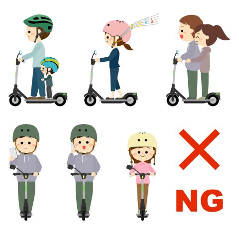
- Don’t wear headphones and don’t use your phone.
4. Learn the skills needed to control your bike.
- Don’t hang grocery bags on your handlebars because they can upset the control of your bicycle and prevent you from turning your front wheel to avoid a crash.
- Riding double is only permitted when carrying a child in an approved carrier or when riding on a tandem bicycle.
- Try to keep at least one metre away from parked vehicles.
5. Maintain your bicycle in good working order.
- Ensure your tires are fully pumped and your brakes are working.
- A mirror is a great safety device to see traffic behind you or a riding partner without turning around.
For more bike safety tips, review the BC Cycling Coalition’s Bike Sense Manual.
Be aware that cyclists have similar rights and responsibilities as people driving vehicles. When driving through Penticton, you’ll find numerous bike paths and routes, some of which are shared and others are separated.
Share the Road
Help reduce the chances of a crash by sharing the road safely. Here are some tips compiled from ICBC and other sources.
- Look out for people on bicycles, particularly at intersections.
- Note that cyclists have designated traffic signals at major intersections and these signals may turn green at different times than the signals for automobiles.
- Watch for areas on the road painted green, such as intersections including Martin Street. Stop behind the green box when waiting at a red light.
- Keep a safe distance from cyclists of at least a metre.
- Watch for cyclists’ hand signals indicating their intention to turn.
Here are some tips to ensure a safe journey for pedestrians.
- Don’t walk in the cycle track.
- Watch for people on bicycles and make eye contact wherever possible.
- Stay alert and don’t be distracted, such as by texting while walking.
Hand signal: Turning left Hand signal: Turning right Hand signal: Stopping
Have Questions?
For questions about bike lanes, contact the Engineering Department. To make a suggestion or report a concern, please use our online form.
Engineering Department
Phone: 250-490-2521
Email: engineering@penticton.ca